Pas De Deux: Transit, Highways, and a Century of Contested Ground
It's seven in the morning. Somewhere in Nassau County, Long Island a woman walks four blocks from her front door to the commuter rail station. She passes the Main Street Fish and Chips, the Sweet Tea House, the Village Deli. The station sits at the center of a small downtown that has been there, more or less unchanged since before her grandmother was born. She buys a coffee, boards the train, and opens her book. The Long Island Expressway is somewhere nearby, but she couldn't tell you where.
A few hundred miles south, a man steps out of a downtown Miami hotel and checks his phone. The convention center is a mile away. He could walk, but the sidewalk dead-ends at an on-ramp. Meanwhile, the MetroMover station — elevated, humming — is visible above the parking garages. He rides the loop. It deposits him a few blocks from his destination. He arrives, slightly frayed, eight minutes later than he planned.
And in a subdivision outside Dallas, a woman backs out of her driveway at six forty-five, navigates to a feeder road, and joins the line of cars inching toward the DART park-and-ride. The train platform itself sits in the median of I-635, accessible by a pedestrian bridge over the access lanes. She parks, walks across the bridge with the wind from passing trucks at her back, and boards a train that for the next forty minutes will run more or less directly alongside the freeway she just left.
Today's transit lines and the stations that serve them often share their surroundings with highways and in many cases, they share it uncomfortably. My last post described how I used computer vision to measure the footprint of highways around transit stations nationwide. The headline finding: nearly half of all transit stations in the United States sit within half a mile of a highway.
That number is the tip of the iceberg. Beneath it lies a more complex story about which stations are affected, how severely, and why. a story shaped by decisions made across more than a century that still determine whether a morning trip to the train is easy or arduous.
Nearly Half of All Transit Stations Have a Highway Next Door
The Nassau County commuter and the Dallas park-and-rider both have a highway within half a mile of their station. What differs is everything else — how much of the surrounding landscape the highway consumes, and how close it sits to the platform itself.
Transit planners measure a station's reach by drawing a circle with an 800-meter radius — roughly a 15-minute walk in any direction, the zone where homes, jobs, and shops are theoretically within reach on foot. My analysis examined that circle around 5,116 transit stations nationwide and measured how much of it is consumed by highway infrastructure. The overall finding — 43% of all stations have a highway within that half-mile — understates the variation. What matters as much as presence is intensity: how many lanes, how wide, and above all, how close.
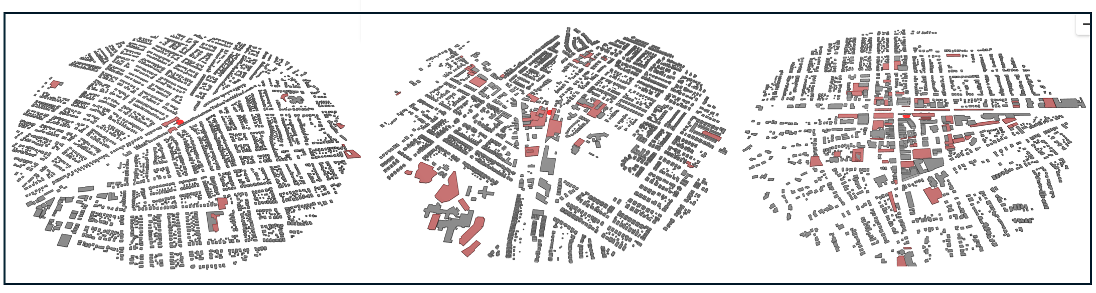
For stations with a highway nearby, the average highway footprint covers nearly 50,000 square meters (roughly nine football fields of asphalt and concrete within walking distance of the platform). But that average obscures the story the images below tell more plainly. As a highway moves from the edge of the catchment area toward the station itself, its footprint grows and its consequences compound. A highway at the periphery is a nuisance. A highway at a transit station’s doorstep is a different problem entirely.
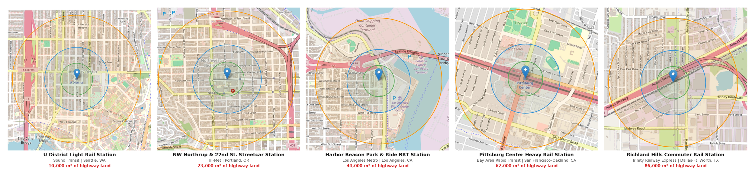
In the above images, the circle closest to the station location (pin) represents a 200-meter radius from the station, the second circle represents a 400-meter radius, and the largest circle represents an 800-meter (1/2 mile) radius from the station.
Consider what it means to walk to a train. In a neighborhood without major barriers, your options radiate outward in every direction — a 15-minute walk traces a rough circle around the station, encompassing homes, shops, offices, the places where daily life happens. Now put a six-lane freeway between you and the platform. Suddenly that circle isn't a circle anymore. It's a shape with a wall in it.
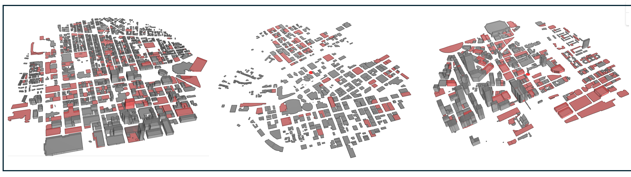
The isochrone maps below make this visible in a way that raw numbers can't. Each map shows the same five stations from the previous images, now colored by how far a person can actually walk in five, ten, and fifteen minutes — orange, yellow, and green layered against what the walkshed would look like if nothing stood in the way.
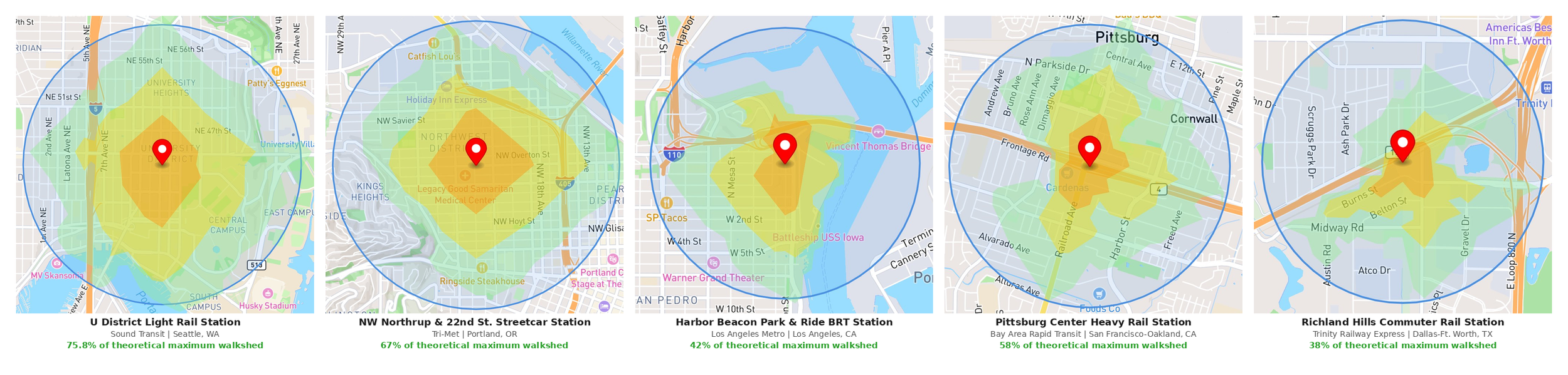
For the U District and NW 22nd and Northrup light rail stations in Portland, the highway exists within the half-mile radius but sits at its edge. The walkshed spreads outward in most directions largely unimpeded. The highway is a problem for the residents unlucky enough to live on the wrong side of it, but it doesn't fundamentally compromise the station's walkable environment.
The Harbor Beacon, Pittsburgh Center, and Richland Hills stations tell a different story. At Harbor Beacon, the freeway combines with port industrial land and the harbor itself to compress the walkshed from multiple directions simultaneously — even the directions the highway doesn't directly block offer limited access. At Richland Hills, built directly in a highway median, the compression is nearly total. The walkshed doesn't have a wall in it. It has walls on all sides. Walking anywhere meaningful requires crossing or paralleling high-speed traffic, and the pale blue circle of theoretical possibility hovers above the map like a rebuke.
The difference between these stations is the difference between a station that anchors a neighborhood and one that exists despite its surroundings.
History Revealed in the Data
Pull back far enough from any one of these stations and the local details give way to something larger: a national pattern with a historical explanation.
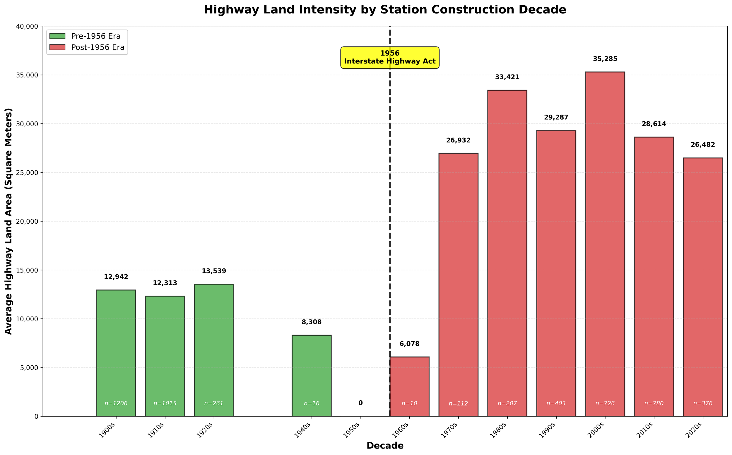
The scatter plot below represents all 110 transit systems in the National Transit Atlas, sized by the number of stations in the system. The horizontal axis measures highway proximity—what proportion of a system's stations sit within half a mile of a freeway. The vertical axis measures highway intensity — how many square meters of freeway land surrounds those stations on average. Systems in the lower left have less of both. Systems in the upper right have more of both.
The pattern that emerges isn't subtle. Clustered in the lower left: New York City Transit, the MBTA, SEPTA, the CTA. Clustered in the upper right: MARTA, DART, LA Metro, RTD Denver. Older systems in the Northeast and Midwest on one side, newer systems in the South and West on the other.
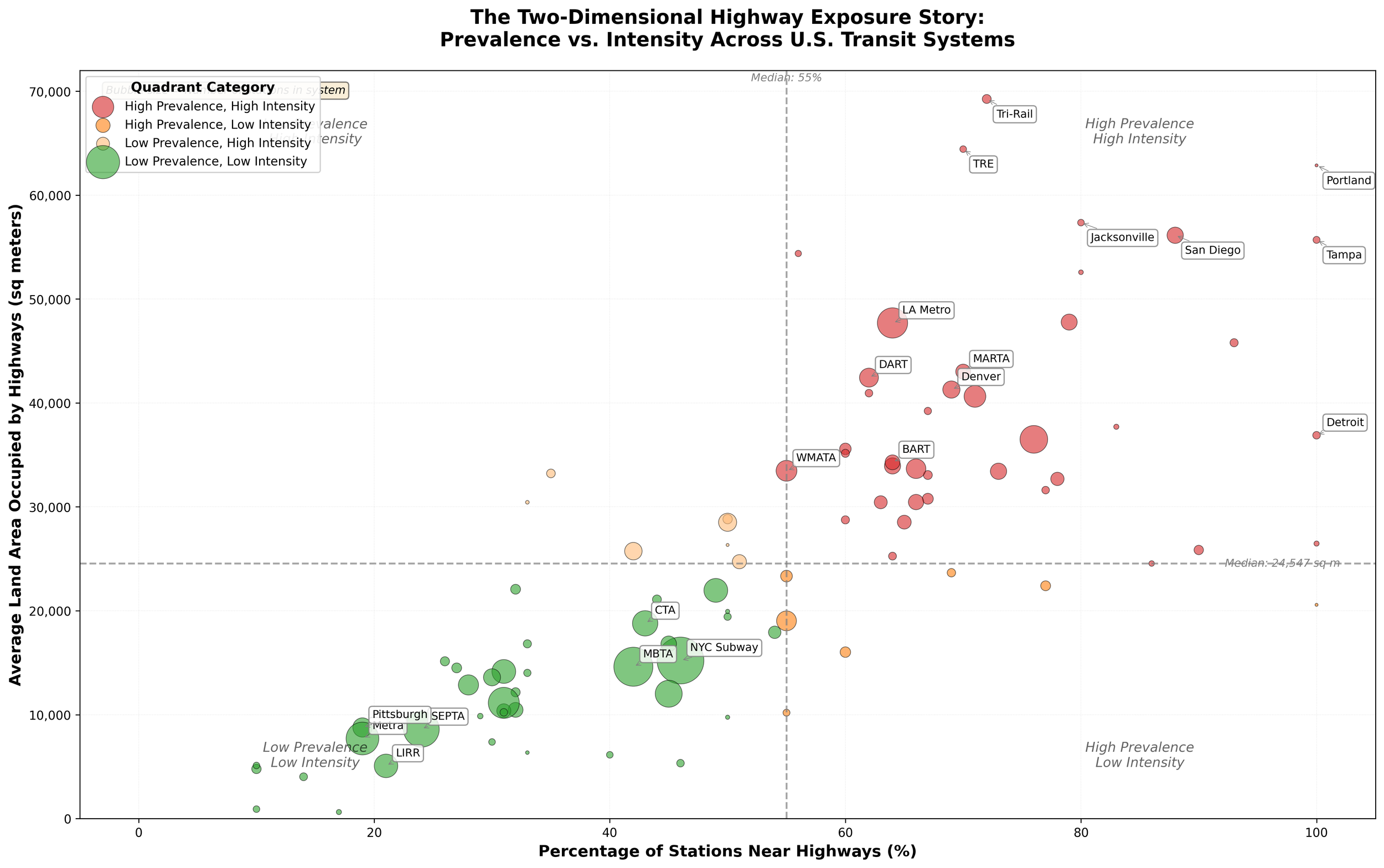
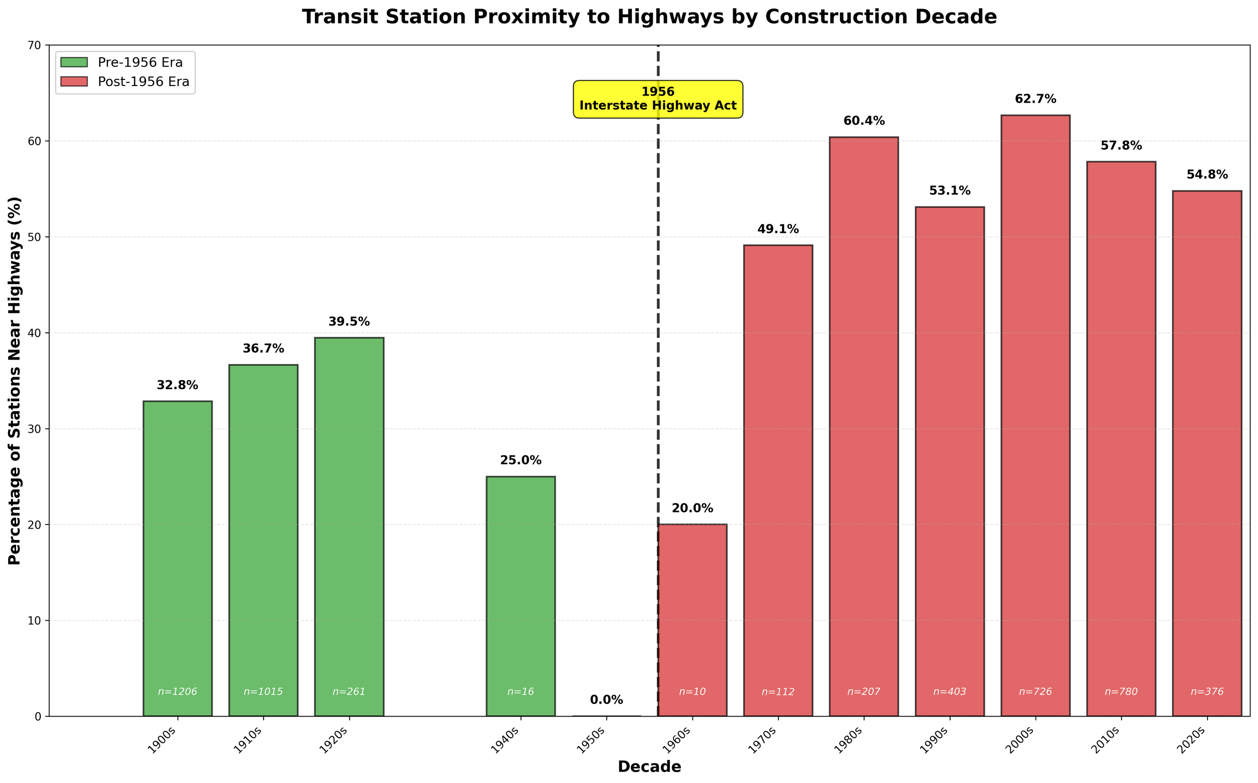
Adding a third variable sharpens this historical divide. When stations are sorted by the decade they were built, the interstate era emerges as a clean dividing line. Between 1900 and 1956, somewhere between a quarter and a third of stations ended up near a highway. After 1956, that share jumps to between half and nearly six in ten and stays there through the present day.
Source: National Transit Station Atlas Public Datasets
When it comes to the amount of land occupied by a highway, the gap is even more striking. Stations built before the interstate era that happen to sit near a highway average about 11,250 square meters of highway land within their catchment area. Stations built after 1956 average nearly 47,500, a 76% increase. Highways near newer stations are bigger, wider, and hungrier for land.
Source: National Transit Station Public Datasets
How did this happen? The answer requires going back further than 1956 — back to when transportation corridors were up for grabs and one mode moved first
Locked In
Picture a game of musical chairs: the contestants walk slowly around a row of chairs while music plays. Once the music stops, contestants scramble for a chair and whomever gets one first gets to keep it. Whomever moves too late is left out for good.
For much of the 19th and early 20th century, transit companies competed for rights of way in and around urban centers. This happened primarily in the Northeast and parts of the Midwest where early industrialization drove transportation investment. The rest of the country had sparse or non-existent transit.
When the Interstate Highway Act arrived in 1956, these systems had already claimed the most direct routes between city centers and suburbs. Highways had to route around them - over, under, or to the side. The transit corridors were protected by existing infrastructure, political inertia, and ridership.
By contrast, when highways claimed their “chairs” in the South, West, and most of the Sunbelt, the transit systems that came later had to find ways to co-exist with freeways.
First Movers: Transit in the Pre-Interstate Era Pre-empts Highways
The transit systems with the lowest highway exposure in our data share a common origin story: they were built by competing private railroads racing to claim territory before anyone else could. Between 1834 and 1910, the corridors that would become the LIRR, Metra, SEPTA, and the commuter rail networks of Cleveland and Pittsburgh were established along river valleys, lakefronts, and colonial-era roads by companies that owned their rights-of-way outright as fee-simple property. By the time the Federal-Aid Highway Act passed in 1956, these corridors were already locked in. They were grade-separated, electrified, and anchored to functioning downtown commercial centers that highway engineers found too expensive and politically difficult to bulldoze through. When Robert Moses built the Long Island parkways in the 1930s and 1940s, he had to route around the LIRR; when the Dan Ryan Expressway was planned in the 1950s, it had to navigate around the Rock Island and Illinois Central infrastructure that had occupied the South Side corridors for a century. The railroads were simply there first.
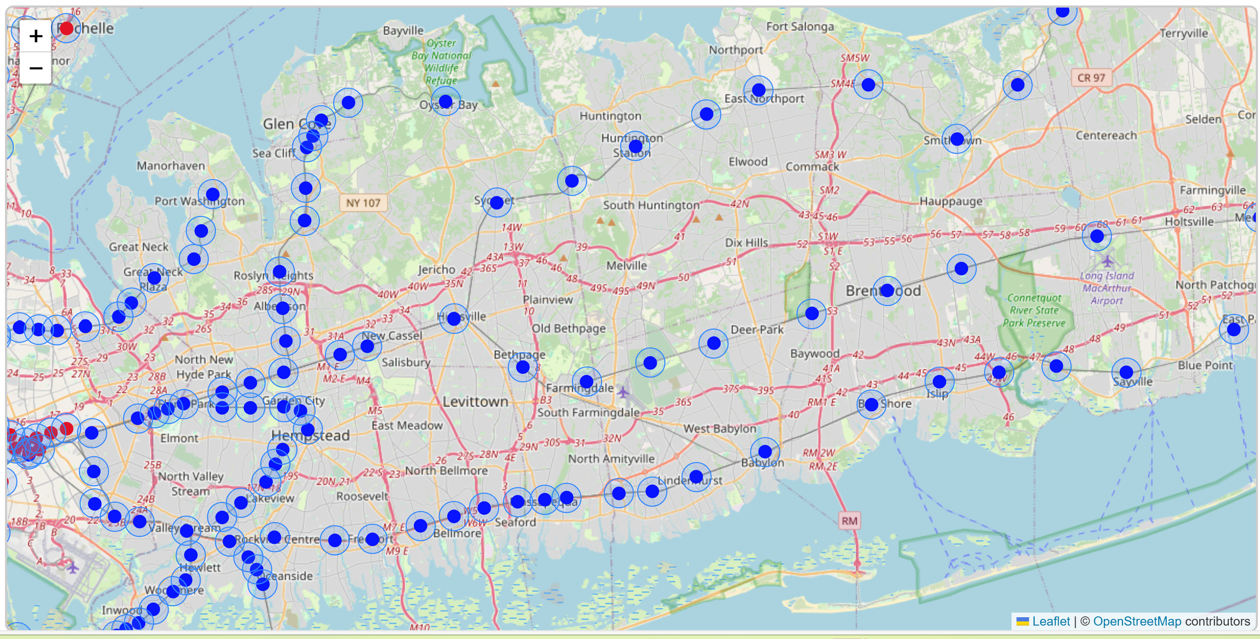
This image shows a portion of stations on the Long Island Railroad commuter rail system (light blue circles represent a ½ mile radius around the station). Overall, 26 out of 126 LIRR stations (20%) are located within ½ mile of a highway.
The geometry of these older systems also worked in their favor in ways that weren't obvious at the time. Chicago's Metra lines radiate outward at angles determined by 19th-century river valleys and township roads, while the city's expressways were built on a cardinal grid. Most Metra lines cross the highway system at oblique angles rather than running parallel to it. In Philadelphia, the Pennsylvania Railroad's 1915 electrification of the Main Line created catenary infrastructure so expensive to relocate that highway planners simply routed the Schuylkill Expressway into the river valley below the rail corridor rather than displacing it. In Pittsburgh, the topography itself made the argument: the South Hills light rail runs through tunnels bored into bedrock in 1904 and 1912, and you cannot build a highway inside a hillside. The Golden Triangle's peninsula geography meant no freeway could penetrate downtown without destroying it, leaving stations like Steel Plaza and Wood Street in walkable urban environments.
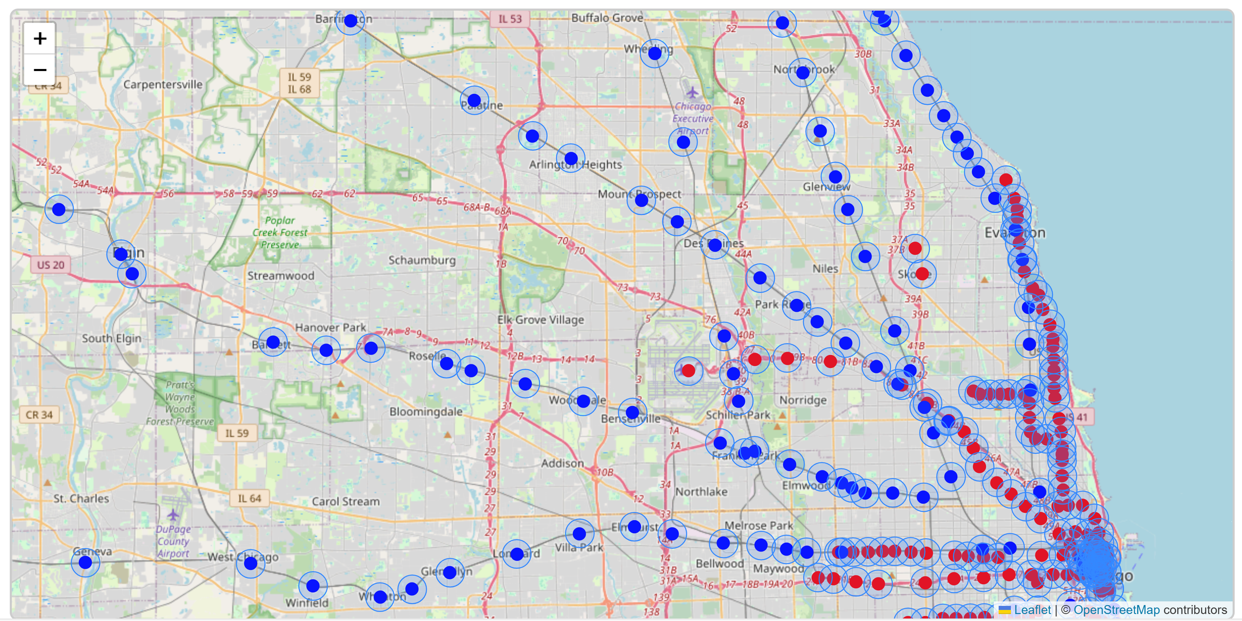
Image shows a portion of stations on the Metra Commuter Rail System (Metra stations shown in blue and Chicago Transit Authority stations shown in red. Light blue circles represent a ½ mile radius around the station). Overall, 44 out of 243 stations (18%) are located within ½ mile of a highway.
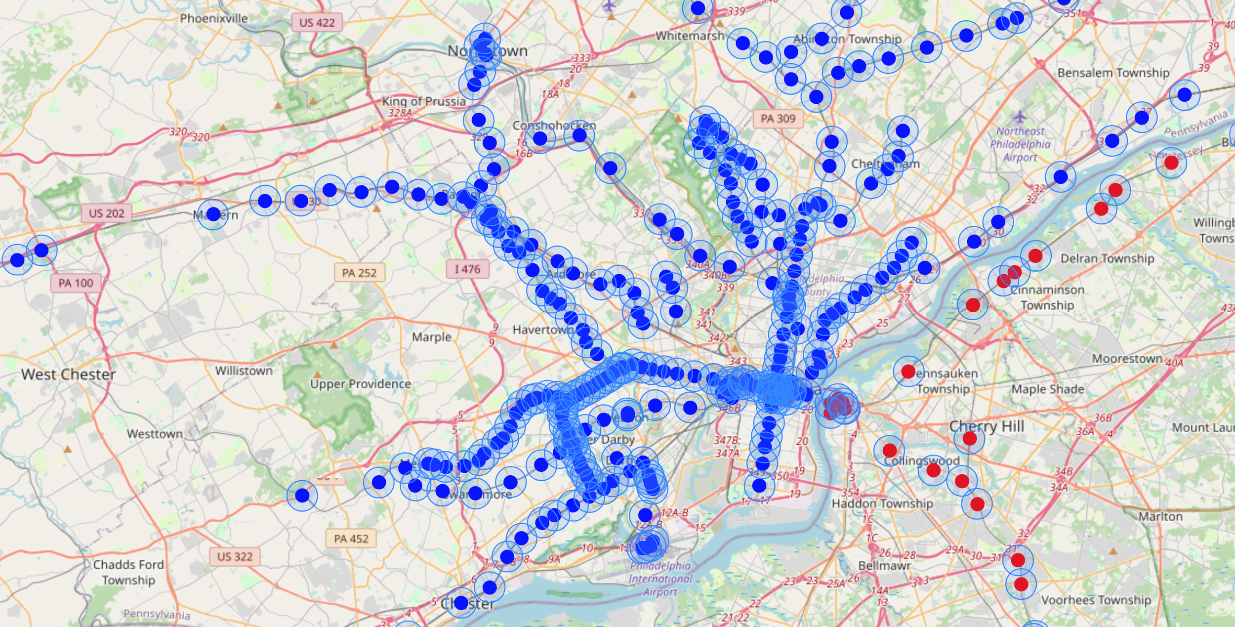
Image shows a portion of stations on the SEPTA system (SEPTA stations shown in blue and New Jersey Transit or Port Authority Transit Corporations stations shown in red. Light blue circles represent a ½ mile radius around the station). Overall, 66 out of 290 stations (23%) are located within ½ mile of a highway.
The suburban stations along these older corridors benefited from a third layer of protection: they were placed, almost universally, in the center of existing village downtowns. The Burlington corridor stations from Chicago to Aurora — Downers Grove, Lisle, Naperville — were built between 1850 and 1870 in the center of functioning communities with street grids, civic buildings, and continuous commercial development. The I-88 tollway was eventually routed two miles to the north, between the communities rather than through them. The LIRR's Nassau County stations sit in the centers of Hempstead, Mineola, and Babylon, downtowns that were fully built out before the automobile existed. Highway engineers, even the most aggressive, rarely chose to bulldoze established commercial cores when empty land on the periphery was available and cheaper.
19th and early 20th century commuter rail lines gave rise to transit-oriented villages such as Westwood (left) on the LIRR West Hempstead Branch, Fox Chase (center), on the SEPTA Fox Chase line, and Downer’s Grove (Right) on the Metra Burlington Northern Line. Development is mainly small residential houses and stores clustered relatively close together on a grid street layout around the station.
Once transit or highways claim a corridor, that land use is locked in for generations. The "first mover advantage" was enormous. Likewise, when it comes to urban land use, prime corridors connecting downtown to suburbs are finite. Some entity claimed the best routes, another entity got the leftovers. Transit that arrived first got the straight shots. Highways got them in most of the country.
Aftermath: Central City Circulators Constrained by Cars
During the interstate era, highways rarely drove straight through central business districts — the land was too valuable, the political opposition too intense. Instead, engineers ringed the urban core. Interstate 75 and I-71 encircle Cincinnati's downtown. I-277 wraps Charlotte's urban core. I-395 and I-95 bracket Miami's Overtown. I-375 and I-75 bound Detroit's central district.
This was not accidental. Urban renewal planners of the 1950s and 1960s often described the highway ring explicitly as a way to "protect" the CBD from surrounding "blight" — a euphemism for separating downtown business interests from the Black and working-class neighborhoods that surrounded them. The highway ring made the CBD accessible by car from the suburbs while cutting it off on foot from the adjacent neighborhoods it displaced. Once the moat was dug, moving people within the enclosed area became a second-order problem.
Examples of urban circulator systems in six cities in the United States.
Decades later, transit sponsors tried to address that problem. Planners added streetcars, bus rapid transit lines, people movers, and monorails to central business districts, hoping to reduce downtown traffic and draw visitors back to the urban core. Results have been mixed.
Urban circulator systems compete with urban parking as well as highways. During the interstate era, cities attempted to lure suburban drivers downtown by building parking on an enormous scale, and the parking never left. The 4.4-mile Miami MetroMover operates within a landscape of 73 parking lots and 20 garages — 7.5 million square feet of car storage within its corridor. The 2.97-mile Detroit People Mover is flanked by 147 parking lots and 25 garages totaling 9.4 million square feet. And in Cincinnati, the 3.6-mile Bell Connector streetcar runs alongside 250 parking lots and 33 garages — 2.8 million square feet of parking for every mile of track.
The images above show ½ mile areas around circulator stations, The 12th and Vine Station area in Cincinnati (left), includes 187 surface lots and 18 garages totaling 5.9 million square feet of parking. The Arts District Station area in El Paso (center) includes 57 lots, 6 garages totaling 1.5 million square feet of parking. The Bricktown Station area in Detroit (right) includes 155 lots, 27 garages for 9.7 million square feet of parking.
The circulators weren't poorly designed. They were poorly positioned — dropped into environments that decades of highway and parking investment had optimized for the car. And car-dominated environments produce car-dominated outcomes. This may change over time. For example, Miami's MetroMover provides free, 24-hour service for 8.8 million annual riders and serves a downtown that has grown dense enough to actually need it. The system has found its footing. Other central business districts have reduced minimum parking requirements after circulators opened. For now though, many of these systems are battling the tide.
Highway Companions: Transit Adapts to the Interstate Era
The pre-interstate transit systems claimed their corridors before the highways arrived. The downtown circulators inherited a highway cage they didn't build. The third category of systems were designed with full knowledge of the interstate landscape, by planners who had watched what highways did to cities and chose, for reasons both practical and political, to build alongside them anyway.
Since the 1980s, a new generation of light rail and bus rapid transit lines has spread across metropolitan America, primarily in the South and West. The interstate system was the dominant fact of the built environment, and planners adapted accordingly. Often, this meant highways in the driver's seat and transit riding shotgun.
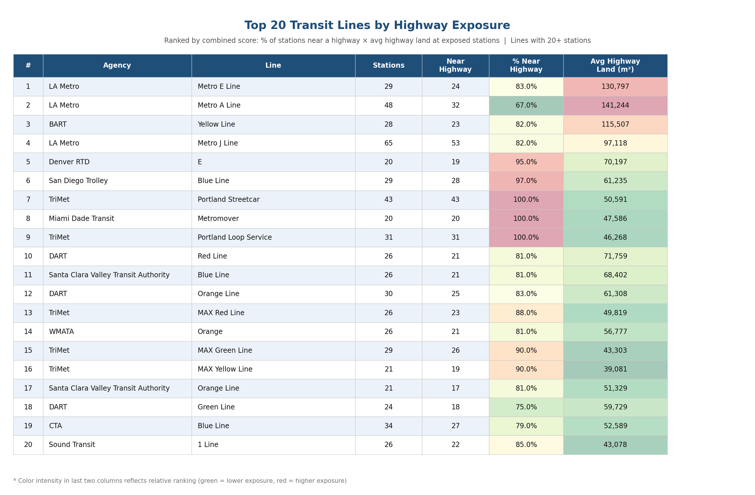
The chart below plots individual transit lines with 20 or more stations, with highway proximity on the horizontal axis and highway intensity on the vertical. The lines clustered in the upper right — the ones with both the highest proportion of highway-adjacent stations and the most highway land surrounding them — read like a map of Sunbelt transit built in the interstate's shadow: Dallas, Denver, Los Angeles, Atlanta.
Source: National Transit Atlas publicly available data
The table that follows ranks lines by a composite score combining both measures. Readers familiar with transit might be surprised to find five Tri-Met lines from Portland in the top 20, given the city's reputation for progressive planning. The explanation is partly geographic: Portland's compact urban form means that the half-mile catchment circles around each station capture more highway land than equivalent circles in more spread-out cities. Highway infrastructure is genuinely dense in Portland's built environment, and the numbers reflect that. But the presence of Portland in this company is also a reminder that no American city fully escaped the interstate era's gravitational pull — not even the ones that tried hardest.
Source: National Transit Atlas publicly available data
How transit ended up alongside the interstate system isn't a single story. It happened four different ways — through inheritance, through intention, through negotiation, and through a kind of defeat. Each mechanism left a different mark on the stations and communities that resulted.
Some modern transit lines run along original freight rail alignments located a stone’s throw from a freeway. Unlike the commuter rail lines of the 19th and early 20th century, these lines did not generate enough economic activity or political support to deter freeway construction next door. Old freight lines also offer transit planners a cheaper and less contentions alternative to acquiring property and potentially displacing homes and businesses.
In Los Angeles, much of the Metro A line follows a highway-adjacent alignment on the former Atchison, Topeka & Santa Fe Railway right-of-way, a rail corridor that parallels and intersects the I-210 Foothill Freeway. Likewise, the E Line follows a historic rail corridor—the Los Angeles and Independence Railroad, built in 1875 and later operated by Pacific Electric until freight service ended in 1987. Metro acquired the right-of-way in the 1990s specifically because it offered a path to build rail transit toward the Westside and Santa Monica along the I-10 corridor. The corridor's proximity to the freeway was part of its appeal to planners: it served the same general market as the I-10 (downtown to the Westside) while using land that was already publicly owned or easily assembled.
This image shows a portion of the Los Angeles Metro A line running parallel to the Foothill Freeway and Arroyo Seco Parkway
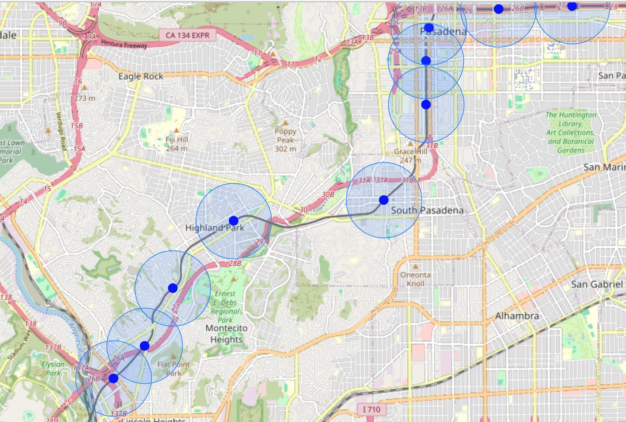
On the other hand, the LA Metro J Line (also known as the Silver Line BRT, which opened in 2009) is an example of transit explicitly designed to operate within a freeway. The line runs in the dedicated bus lanes of the I-110 Harbor Transitway, which was built in 1996 as part of the freeway itself. The Harbor Transitway was conceived in the 1980s as a way to provide HOV lanes and transit access along the congested I-110 corridor.
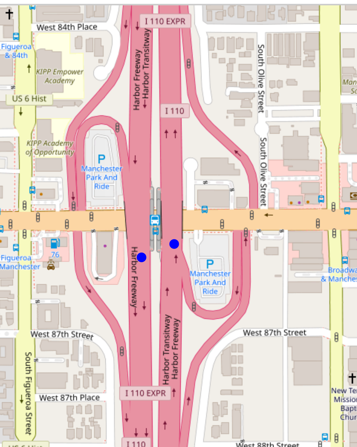
The blue dots are the approximate locations of the northbound and southbound Harbor Transitway/Manchester bus rapid transit stops.
Denver's T-REX project began as a transit study. It recommended light rail, safety improvements, and enhanced transit management along the I-25 corridor — and notably did not call for additional highway lanes. What emerged from the negotiating table was something else entirely. After the Federal Highway Administration, the Federal Transit Administration, CDOT, and RTD finished reshaping the project, T-REX had become a $1.67 billion joint highway reconstruction and light rail extension. The FHWA wanted the light rail alignment shifted from the western shoulder of I-25 to the extreme edge of the right-of-way "to preserve as much right-of-way as possible for highway uses." The final plans widened I-25 from six to eight or ten lanes, widened I-225 from four to six lanes, and reconstructed seven interchanges. The RTD E-Line — 19 miles of double-track light rail with 13 new stations — was the price CDOT agreed to pay for highway expansion. The highway expansion was the political vehicle that made the transit investment possible.
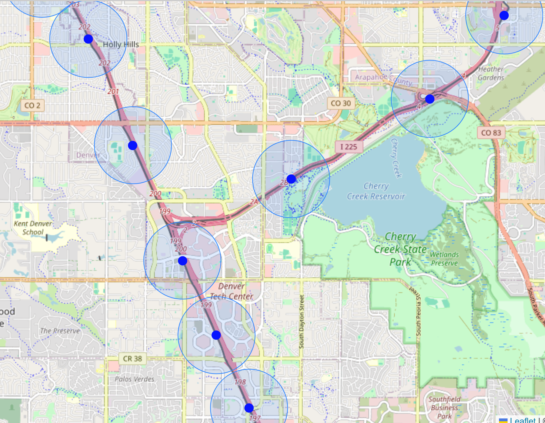
This image shows a portion of the RTD E-Line with stations on the I-25 and I-225 medians
In the Bay Area, the BART Yellow Line's eastern extension into Contra Costa County ended up on the freeways after the preferred plan collapsed due to freight railroad obstruction. The original 2002 proposal envisioned trains running along the Union Pacific Railroad's largely inactive Mococo Line, a freight corridor that ran parallel to State Route 4 through Pittsburg, Antioch, Oakley, and potentially all the way to Byron. The Mococo offered a grade-separated right-of-way through established communities without requiring highway adjacency. But Union Pacific declined to grant trackage rights or allow laying of new tracks, declaring it needed the Mococo Line to relieve freight traffic on the Martinez Subdivision even though the line was largely inactive, used to store freight cars at the time. With the railroad corridor unavailable, BART faced a choice between abandoning the extension entirely or pivoting to the only other feasible alignment: the median of State Route 4, which Caltrans was already planning to widen as part of a separate highway expansion project. Highway adjacency became the path of least resistance.
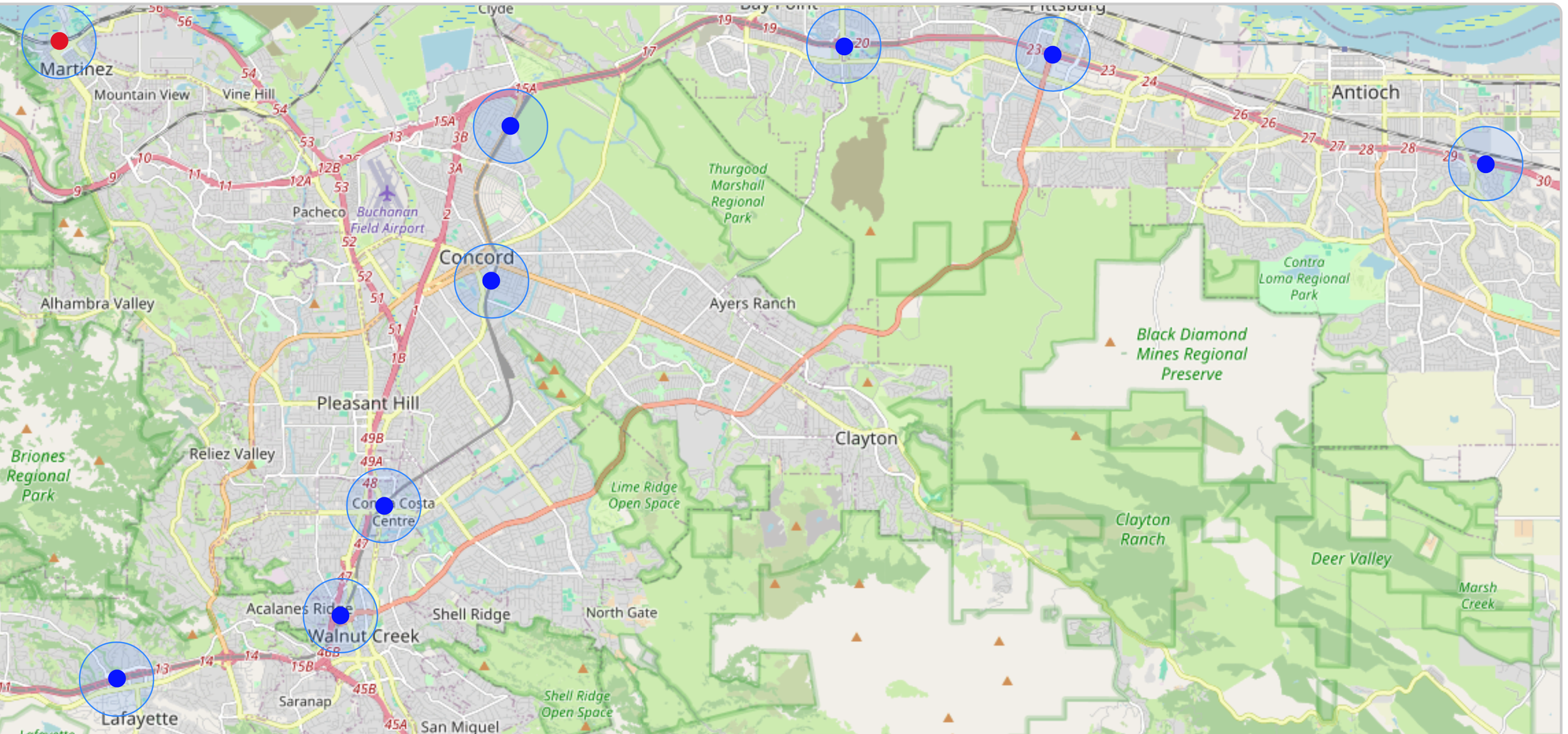
This image shows a portion of the BART yellow line with stations located on State Route 4.
As was the case with urban circulators, many modern suburban transit stations are surrounded by parking, but for different reasons. Parking accumulated over decades in many urban cores. It was an artifact of urban renewal policy that transit systems inherited and struggle to overcome. Around the new suburban light rail stations, parking was part of the original blueprint. Planners built park-and-ride lots on the working assumption that the only way to attract riders in a car-dependent metropolis was to meet them where they were: behind the wheel.
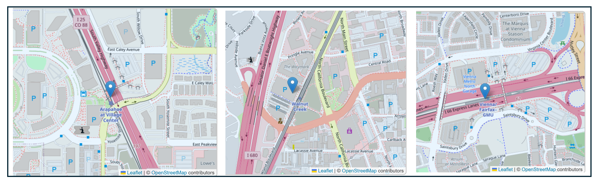
Park and ride lots at the RTD Arapahoe Village station, the DART Walnut Creek Station, and the WMATA Vienna Station
That assumption wasn't unreasonable. Travel times matter, and a light rail line running alongside I-25 can move a commuter from the suburbs to downtown faster than the freeway on a bad morning. But the assumption also carried a cost that didn't show up in the ridership projections. When you design a transit system around the premise that riders will drive the first leg of every trip, you've already answered a question that the pre-interstate planners never had to ask: what is a transit station for? In the park-and-ride model, the answer is a transfer point, a node. Not a destination, not a place, not the center of anything.
The woman in Nassau County is probably on her second cup of coffee by now, somewhere under the East River, her book open in her lap. The man in Miami made his meeting, slightly frayed. The woman in Dallas is downtown, her car in a lot by the freeway, her train already running the return trip without her.
Three commutes. Three different relationships between a person, a station, and a century of decisions about where to pour concrete and lay track. The Nassau County woman inherited a system built before anyone asked what a highway was. The Dallas woman uses one built with the highway already in mind. The Miami man is somewhere in between — served by a system that was handed a difficult problem and did the best it could with it.
None of this was inevitable. The corridors that became freeways in Atlanta and Dallas and Denver were, at some point, open ground. The park-and-ride lots that surround suburban stations were, at some point, design choices. The highway rings that cage downtown circulators were, at some point, proposals on a planner's desk. Decisions made them permanent — or at least made them feel that way.
But land use is never truly permanent. Cities have begun removing urban highways. Parking minimums are falling. Transit-oriented development is reshaping station areas that spent decades as transportation nodes. Once we understand how the landscape got this way, we are better able to make deliberate, constructive change.